Yes it’s amazing, it’s astounding, and it’s damn near religious! the Flat Earth Society really exists! You can check them out here:
http://www.theflatearthsociety.org
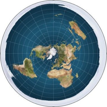
This of course is a society that believes our Earth is a flat Earth. A disk where Gravity is upward acceleration to achieve a gravity equal to: g = 9.81 m/s2.. However, we are not here to talk about Gravity, the flashlight Sun just 3000 miles above Earth, the invisible black disk to explain away eclipses, or bendy light to explain the setting sun and sinking ships over the horizon.. No no no, we are going to address the very heart of this by addressing their projection Map of Earth. Though they will enjoy this free publicity for a shot at your science literacy to get you to believe the Earth is flat, but what they don’t have is a map, a navigable map with an accurate coordinate system.
Thus I present you with the FLAT EARTH! :
–
Yup that’s it, and with a huge ice wall in which the governments of the world conspire to protect from prying eyes, and FE explorers. Yes it gets crazy deep into conspiracy theories to the point of comic relief. However, by looking at this map we can see some things that are quite obviously wrong here. But the most noticeable detractors can best be stated as follows:
* No GPS coordinate would ever work on this map.
* Here we have severe warping of the continents.
* Distances between continents ridiculously increase as you expand out from the North Pole.
* No information or detail in terms of coordinates, or exact scale
* It’s a Cartoon with a satellite projection map!
So many of us would automatically call it a day just by those simple observations of the Map.. However, the ignorance of whether or not this concept fits our observations in the real world is a bit more challenging. Hence, if you walked out your door from where you live now, how would you know that Earth isn’t laid out in such a manner? How would you know if the Earth wasn’t dome shaped with a flat bottom? .. It gets difficult when all images and government data are scoffed at as conspiracy, doctored, bias, or RE (Round Earth) propaganda against the truth of FE (flat Earth). It begs the question of how can we prove it to ourselves rather than the Flat Earthers that will just religiously deny everything? Well, I had taken the time to do some math to find out if I could, and I did this out of fun really, so I hope all of you enjoy this Debunking of the Flat Earth Society’s projection Map.
Step 1:
The first thing we must do is establish what they claim to be the diameter and circumference of their flat Earth. So here are the figures straight from their own FAQ, or Wiki:
http://www.theflatearthsociety.org/forum/index.php?topic=1324.msg566287#msg566287
Circumference: 125,891 km (78,225 miles)
Diameter: 40,073 km (24,900 miles)
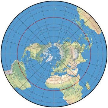
Now there is a key thing to note here in order to understand what they did to get these numbers, and that is that they literally took Earth’s circumference, at the Equator, and used it as their Diameter. Sneaky bastards? Well, if you are to keep any sort of scale to which you can use as an ignorance tool in a debate, this would be absolutely necessary. It’s how you unfold a sphere into a circle. But it’s also because they know they can’t do an equal area projection map without severe distortion such as the following example demonstrates :
As you can see that Equal area distortion can be quite extreme. Though navigable if you calculate for the distortion. However, the calculations would invalidate it as a map reflective of the real world.. So in light of this unarguable fact, we can finally address the Flat Earth Society’s projection map. Thus in step 2 of this article we will break down the Map into a basic mathematical understanding to expose why such a map is so deceptive, wrong, and not applicable to the real world!
Step 2:
Before we Start we must recap on FE’s stated Diameter and Circumference:
Circumference: 125,891 km (78,225 miles)
Diameter: 40,073 km (24,900 miles)
Firstly there is a small mathematical correction to make. A diameter of 40,073 Km is 24,900.2077 miles. When you take this and times it by 3.14(PI), you get the circumference of 78226.3095 miles.
* — Breaking up the Map into Segments/blocks — *
* This map has 12×24 blocks for a total of 288 blocks all together.
* Here we have a radius of 12 blocks starting at the north pole.
* North Pole = point 0, and the beginning of Block 1
* These 12 blocks will be our radius, and for sake of argument, they will all be equal in height.
* The 24 blocks across the entire width will be our Diameter
* All Blocks will be in miles for Height and Width
* All Blocks will be in square miles for Area
So in understanding that FE’s diameter, given above, is 24,900.2077.. We can find the radius height of all the blocks by dividing FE’s diameter of 24,900.2077 by 24 blocks to get 1037.50865416 miles in height for each block of the 24 blocks. These two numbers will be important to remember.
Legend:
Diameter 24,900.2077 miles
Radius 12,450.10385 miles
Circumference: 78,226.3095 miles
total area: 486,962,839.0564 sq miles
center angle: 15 degrees
Blocks: 288, 12hx24w
Sector Area: 20,290,118.294016 sq miles
Sector Sector Arch Legnth: 3,259.4296 miles
Sector Chord Length 3,250.1293 miles
Block Area: 230,984.1378 sq miles
* — Center Angle — *
The center Angle is 15 degrees
* — Radius — *
with a radius of 12,450.10385
* — Diameter by Block — *
Per Block Radius: 1037.50865416
Formula 1: Block (#)(2)(1,037.5086)
0: 0 miles
1: 2,075.0173 miles
2: 4,150.0346 miles
3: 6,225.0519 miles
4: 8,300.0692 miles
5: 10,375.0865 miles
6: 12,450.1038 miles
7: 14,525.1211 miles
8: 16,600.1384 miles
9: 18,675.1577 miles
10: 20,750.1730 miles
11: 22,825.1903 miles
12: 24,900.2077 miles
* — Circumferences by per Block Distance from the North Pole — *
0: 0.xxxx miles
1: 6,518.8591 miles
2: 13,037.7182 miles
3: 19,556.5773 miles
4: 26,075.4364 miles
5: 32,594.2955 miles
6: 39,113.1546 miles
7: 45,632.0137 miles
8: 52,150.8728 miles
9: 58,669.7319 miles
10: 65,188.5910 miles
11: 71,707.4501 miles
12: 78,226.3095 miles
The Area by Block distance from the North Pole:
0: 0 miles
1: 3,381,686.3551 sq miles
2: 13,526,745.4206 sq miles
3: 30,435,177.1965 sq miles
4: 54,106,981.6827 sq miles
5: 84,542,158.8793 sq miles
6: 121,740,708.7862 sq miles
7: 165,702,631.4035 sq miles
8: 216,427,926.7311 sq miles
9: 273,916,594.7691 sq miles
10: 338,168,635.5174 sq miles
11: 409,184,048.9760 sq miles
12: 486,962,839.0564 sq miles
* — TOTAL AREA — *
486,962,839.0564 sq miles
Part 3
CONCLUSION:
Well I hope you made it through all the Math! But what’s interesting is what we can derive from it. What we can compare the known Earth in relation to this supposed Flat Earth, and what you will find is that there is a huge amount of differences that would cause all kinds of problems. These include:
> fuel consumption..Fuel costs and consumption would be unknown magnitudes higher
> Flight times..Imagine trying to fly from Boston to Japan!
> shipping costs would be insane!
> food costs would sky rocket!
> The notion of sailing around the world seem likely the impossible!
> Climate Change
> Weather Patterns
> Jet Streams
> Animal and Bird Migration
This list could go on and on! However, to give you an idea of what I am talking about, I have provided you with a comparison if we were to try and keep things to scale:
Total Area Comparison:
FE:
Surface area: 486,962,839.0564 sq miles
percent of Earth’s ocean 70% – 340,873,987.33948 sq miles
percent of Earth’s land: 30% – 146,088,851.71692 sq milesRE:
Surface area: 196,935,000 sq miles
percent of Earth’s ocean 70% – 137,854,500 sq miles
percent of Earth’s land: 30% – 59,080,500 sq miles
So what happens when you try to unfold a sphere and convert it into a circle is that you have to add mass area. This is because unfolding a sphere is like peeling a banana, and you end up with a pin wheel with gaps in between. These gaps must be filled in, and thus mass area is then added to complete the circle. So this is why FE’s surface area is 486 million sq miles vs RE’s 196 million sq miles.
So we are left with a question:
If we did a time speed and distance calculation (estimated), How long would it have taken Columbus to sail around the world?


Great blog, mate. This is Grisham from News Vine. I’ve added your blog link to the link list on my blog so I can keep up on your stuff.
LikeLike
Hey Grisham, …Awesome to see ya in the blog world! 🙂
I will add a link to your blog as well. Though you are leaving NV, I am glad you haven’t decided to stop writing. Your content is among the select few I would take the time to read on NV. I hope you bring all your articles you’ve written over to your blog.. I also need to convert those on the vine to hard disk. 🙂
As for me, I’ve spent a lot of time overhauling my articles on my blog, and prepping my old NV articles for this blog.. Good news though, I restarted putting together that article on Lucy I lost.. 🙂
Sincerely your Friend,
Will
LikeLike
Neat! I bookmarked Grisham’s and your blogs so I don’t lose track of your articles and thoughts.
LikeLike
you forgot to take into consideration the spinning of the earth disk in flat earth theory
LikeLike
The spinning Earth disk is an incoherent response to this article.. The argument wouldn’t address navigable coordinate systems in relation to time and distance calculations.. Hence, yeah we can pretty much rule that argument out immediately. 🙂
LikeLike
In FE, the Earth is not moving.
LikeLike
Hello Jon, I would have to disagree in that, according to them, they argue that Earth constantly accelerates upwards at 9.807 m/s² … Hence, yes they do argue that it is “moving”.. 🙂 However, in that case Earth’s gravitational field would have to be completely uniform, or the acceleration would have to be completely uniform across the entire mass and area of the planet.. If it weren’t it would rip itself apart. And well, any non-local measurements of Earth’s gravitational field would quickly destroy that claim as Earth’s gravitational field is not uniform, especially when it’s an oblate sphere and that you will weigh differently at the poles than you will at the Equator.. 😉
LikeLike
It doesn’t matter how hard some people will try to hide the truth…very soon, no one will need to explain anything…it will be self explaned…and openely visible…
LikeLike
It already is openly visible… Just get a camera and a weather balloon and call it a day 😉
LikeLike
How come you can’t track any flights over the south pacific going from say, Rio to Sydney or anywhere else. They all drop off of every plane flight tracking GPS website and reappear just before they land. Also the shortest way to get from, for example, Capetown to Sydney would be straight over the ocean, but all flights go north over there land. Is the ocean to big? Enclosedworld.com
LikeLike
No civilian radar coverage over the middle of the ocean is part of the reason.. it helps to know how radar works.., and the military assests are not avaiable to public access.
LikeLike
Hello, I am a member of the flat earth society, and no offence to you but you are ignorant to some historical events that have happened that disprove your whole article. One, every country in the world has signed the Antarctica treaty calling it a no sail or fly zone, and why would they do that. In the 1900s, 3 expeditions were set out to map Antarctic, and their results were the inability to make it past 50 miles in, and guess what they found only 50 miles in, enough to coal to fuel the entire world for 100 years, and that is only the coal they saw. Why the hell would they sign a treaty making it unusable. As you probably know, governments are greedy, and want money. Two, you answered a comment about the not being able to track flights in the Southern Hemisphere, you used faulty logic. Your answer was that civilian radar doesn’t reach out there. If it doesn’t then why do all the flights in the northern hemisphere over the Pacific Ocean, for example, have visible tracking. The ocean is the same length everywhere mostly. I could go on and on about how your are wrong, and can finish this discution on my email greekgods2@yahoo.com and we can see if the world is really flat or not. Please respond to my comment so I can know your ideas
Thanks, Robert
LikeLike
None of which you wrote disproves anything noted in this article.. You can feel free to provide a navigable coordinate system and equal area map..
” for example, have visible tracking.”
Any such data does not come from civilian radar, it either comes from cleared military or satellite GPS tracking.. There are no civilian radar stations in the middle of the ocean.. Let me know when you have more than appeals to ignorance and a cartoon that uses a satellite projection map for a map.
LikeLike